Wednesday, 16 October 2019

Visitors from Misato

I have recently become Treasurer of Hebden Bridge Walkers Action. Yesterday we were visited by seven representatives of the town council of Misato in Japan. They came to Britain to find out about Walkers are Welcome towns as they are planning to set up something similar in their home town.

At the weekend they attended the Walkers are Welcome conference in Kirby Stephen and stayed in Otley before coming to visit us in Hebden Bridge. They came here because Hebden Bridge was the first Walkers are Welcome town. They were welcomed by the Mayor and Deputy Mayor of our local Town Council, HebdenRoyd. There was a discussion and an exchange of ideas followed by coffee and cake.

Visitors from Misato with the Mayor

Walkers Action then accompanied the visitors on the bus up to Heptonstall. After a quick look around the historic village we walked back down to Hebden Bridge for Lunch in the White Lion.

Hebden Bridge Walkers Action have signed a Memorandum of Friendship with Misato in which we agree to support each other to:
  • Encourage towns and villages in our respective countries to be "Welcoming to Walkers".
  • Offer local people and visitors excellent walking opportunities.
  • Promote the health benefits of walking.
  • Increase participation in walking.
  • Encourage the use of local transport.
  • Ensure that footpaths and facilities for walkers are maintained, improved and well signposted.
  • Encourage appreciation of the local countryside, landscape, cultural heritage, and ecology

It was wonderful to meet people from Japan who are as enthusiastic as we are about these objectives.

Thursday, 26 September 2019

Derwentwater and Munrobagging III

Since my last post, I have had two weeks at HF Derwentwater leading Guided Walking and a week at HF Glencoe leading Munrobagging III. The weather was pretty wet in the Lake District although there was one memorable day when I took 21 people to the top of Scafell Pike. The cloud was drifting around but we got some good views. Very satisfying.


Descending from Scafell Pike along The Corridor Route
On Munrobagging III there was, thankfully, less wind than we had on MBI and MBII (see previous post). 11 people signed up for MBIII, which is a fair sized group on fairly challenging walks. They were good walkers and we made good progress.

My general approach is not to walk too fast but not to stop too much either. Ideally you should be able to keep up a conversation without getting out of breath, although sometimes this isn't possible if it gets very steep. I like to stop for 15 minutes for elevenses, 20 minutes for lunch and to have a short break on the way down to give weary knees a rest. We might stop occasionally for a drink, or to look at the view, but I try to walk slowly enough to allow everyone to keep up, so that we don't have to keep stopping to let people catch up. I like to keep the same pace going all day and just shorten or lengthen my stride to deal with uphill or downhill slopes or awkward terrain. Again - this isn't always possible.

If people want to walk a bit faster and go ahead, that's fine - so long as they don't get too far ahead. A couple of minutes is a good rule of thumb but they need to bear the following in mind:

1) Do they know the way?
2) Is the rest of the group in sight?
3) By getting ahead, are they putting pressure on the people near the back to rush? This can be very demoralising if you are at the back of the group.
4) What would happen if someone had an accident? Could we easily get the group back together to manage the incident?

We had a particularly memorable day when we walked from Elleric in Glen Creran to Glencoe, via Beinn Fhionnlaidh and Sgor na h-Ulaidh. This was the first time I had done the walk with a group and perhaps it was just a bit too big a walk as we got back an hour late. However, the memorable aspect was the cloud inversion. We spent nearly the whole day in cloud except for when we reached the summits, where we emerged into the sky above the clouds and looked out at all the tops over about 950 metres sticking out of the clouds. Incredible!

Beinn Fhionlaidh and Ben Cruachan from Sgor na h-Ulaidh

Ben Nevis, Aonach Mor, Grey Corries, Bidean & Sgor na h-Ulaidh from Beinn Fhionlaidh

Descent from Sgor na h-Ulaidh (The Hill of the Treasure!)

Friday, 19 July 2019

High Winds!

Back to Glencoe with HF Holidays again. This time I was leading two Munrobagging holidays. Munrobagging I, home for a week and then back for Munrobagging II. Munrobagging involves ascending mountains over 3,000 feet high in Scotland. You can find more details in a previous post.

Last year I had three weeks of amazing hot weather in the area. This was pay back time! During both weeks it rained quite a lot but more importantly it was very windy. This meant that we had to change or abandon several walks.

The Beaufort Scale is very useful for understanding a forecasted wind speed. The initial scale related qualitative wind conditions to effects on the sails of a frigate, then the main ship of the Royal Navy, from "just sufficient to give steerage" to "that which no canvas sails could withstand". In 1916, to accommodate the growth of steam power, the descriptions were changed to how the sea, not the sails, behaved and extended to land observations. Here is a summary:

Wind Speed (mph)
Effect on land
< 1
Smoke Rises Vertically
1 to 3
Direction shown by smoke drift but not by wind vanes.
4 to 7
Wind felt on face; leaves rustle; wind vane moved by wind.
8 to 12
Leaves and small twigs in constant motion; light flags extended.
13 to 18
Raises dust and loose paper; small branches moved.
19 to 24
Small trees in leaf begin to sway; crested wavelets form on inland waters.
25 to 31
Large branches in motion; whistling heard in telegraph wires; umbrellas used with difficulty.
32 to 38
Whole trees in motion; inconvenience felt when walking against the wind.
39 to 46
Twigs break off trees; generally impedes progress.
47 to 54
Slight structural damage (chimney pots and slates removed).
55 to 63
Seldom experienced inland; trees uprooted; considerable structural damage.
64 to 72
Very rarely experienced; accompanied by widespread damage.
> 72
Devastation

For me, the maximum you can walk in is gusts of 40 mph. Once it gets above 40 mph you can't really make progress any more. You have to keep stopping and putting a hand on the ground or lean on a walking pole.

You definitely would not want to be on an exposed ridge or anywhere near a big drop if the wind is much above 30 mph. Especially if it is gusting. When you get gusts of wind it can suddenly unbalance you.

The problem we had though, is that you are reliant on a weather forecast. Wind speed can vary greatly from one mountain to the next. It is possible to get a specific mountain forecast. You can use the excellent MWUK Phone App or just enter the name of a summit on the Met Office Website. However, it is only a forecast and in the Scottish Highlands forecasting is difficult. I am therefore loath to tell people day after day that they won't be bagging any Munros but I don't want to end up in a dangerous situation.


If I didn't like the forecasted wind speed, I adopted the following policy: If we could go and see if it was possible and have a way back then we'd give it a try. Otherwise we'd just go somewhere else. However, the 'go and give it a try' option had to result in a descent walk if we had to turn back.


When it was dry, I did get some good photographs though:


The 'Lost Valley' and Glencoe from the ridge above

Andesite on Bidean nam Bian. It was once lava but it has shattered due to sudden cooling

Grey Corries from the slopes of Sgurr a' Bhuic

Tame Bucks
I also had the opportunity to visit the excellent West Highland Museum in Fort William where they have this incredible portrait of Bonny Prince Charlie.


Anamorphic picture of Bonny Prince Charlie

"After the the Battle of Culloden in 1746, it was treasonable to support the Stuart claim to the throne. When the ladies and servants had left the room after dinner, the loyal friends of Prince Charles would place the tray on the table and raise their glasses in a toast to his likeness reflected in the cylinder (or in a goblet of claret). If there was a danger of interruption and discovery, the device could quickly be dismantled and the tray would appear as a meaningless blur, or be replaced by a similar decoy tray.

The artist is unknown and there is no record of the portrait’s owners. It was discovered by chance in a London shop by the founders of the Museum and is one of [their] best known exhibits." From the WHM website.

The painting is an example of a technique called mirror anamorphosis. The most famous anamorphic painting is the skull in Holbein's "The Ambassadors".

The museum is free and is packed with all sorts of interesting things. The other place I would recommend in Fort William is the relatively new Highland Bookshop.

Wednesday, 5 June 2019

A Change to the Rules for Hiking Guides in the South Tyrol

Sadly, I won't be able to go back to the South Tyrol as an HF Holidays Leader and the trip to Selva in the Dolomites in a month's time has had to be cancelled. The Administration of the Province of Bolzano have changed the rules about who can be a Hiking Guide in the South Tyrol. They define as a  'Hiking Guide' someone who accompanies hikers without crampons, ropes or ice axes on paths without fixed-ropes or other equipment and away from glaciers. This is what I do.

It goes on to say that the professional qualifications of these guides must be obtained through attendance at own's own courses and after passing the appropriate exam at the Association of South Tyrolean Mountain and Ski Guides.

There is a UK qualification that I could obtain called 'International Mountain Leader' that would be acceptable. This qualifies you to lead in the Alps in both Summer and Winter conditions but I am only interested in the former . From now on, in the South Tyrol at least, HF Holidays will need to employ someone with the necessary qualifications.

To become an IML you must first qualify as a UK Mountain Leader and have a certain amount of experience internationally in summer conditions. OK so far, but you also need more international experience than I have in winter conditions. So I'd have to get out and do that.

After that, you take the IML summer training course in the UK, which includes a timed navigation test in the mountains. This is followed by a summer assessment course and a winter training course, both in the Alps. Finally, and after more experience has been built up, you have to pass a winter assessment course in the Alps.

A lot of this might be enjoyable but it would cost a lot of money and it seems a bit rich to insist on winter experience as a pre-requisite for leading in the summer.

If the result of this is that both local and European guides get more paid work then I shouldn't complain of course. I hope it works out that way.

Of course none of this prevents me from going to the area with Dorothy and other friends and this is something I will definitely be doing in the future.

Schenna

The hotel used by HF Holidays in Schenna is totally amazing. It is called Schenna Resort because it is several hotels combined into one. You can watch this short film to get an idea of the facilities. They focus on 'Wellness' and offer lots of free activities during the day. Take a look at this weekly program.

Schenna Resort - Weekly Program
The theory is that Wellness Holidays improve physical well-being, happiness, and productivity, giving you a fresh perspective, improving creativity, resilience, problem solving, and capacity for coping with stress. I concur and I think that this also applies Walking and Cycling Holidays in general.

The hotel does offer short walks but mainly concentrates on spa type treatments. The concept is not new. Merano, further down the valley from Schenna, has been a spa town for a long time. Their favourite visitor was Empress Elisabeth of Austria. She arrived in the autumn of 1870 with an entourage of 102 for an extended stay to try to improve the health of her two year old daughter. Sissi, as she is affectionately known locally, was a keen walker and she returned to the town on three further occasions. On one of our walks we saw a sign by a tap sticking out of the wall in the forest explaining that she had drunk from it!

It is a fantastic area for walking. You can use cable cars to gain access to paths that wind their way, high up across the hillside. Sometimes crossing cliffs that seem impenetrable. Look at these pictures taken on two sections of the Meranoer Hohenweg.

Looking down at the next section of the path and the suspension bridge

The well engineered suspension bridge

Climbing back up again to regain lost height

Goats on the track. They weren't moving from that shady spot!
Some of the walks had to be adjusted because there had been a lot of late snow. Apparently the last few weeks had been 10 degrees colder than average and the coldest for 29 years.

We walked through here

We didn't walk across that!
On another walk we went up the very modern Merano 2000 cable car and got off at the mid-station. It reminded me of the sort of thing you might see in the original 1960s Thunderbirds Are Go TV Series.


 You can visit the Trauttsmansdorff Botanical Gardens, head down to Merano, visit Ötzi in Bolzano (see previous post) or just admire the incredible views.

A flower meadow at Trauttsmansdorff Gardens

A view of the Dolomites

Wednesday, 15 May 2019

The South Tyrol

I am going to be leading walks for HF Holidays at two resorts in the South Tyrol over the next couple of months so I thought I'd do a bit of research into the area. It is the most northerly province in Italy and was once part of the Hapsburg and then Austro-Hungarian Empires. Consequently about 60% of the population speak German as their first language, 20% speak Italian and 4% Ladin. Also, according to a poll conducted in 2013, 46% of the population still favour secession from Italy. It is an unusual and interesting place in many ways.
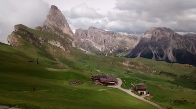
A photograph I took when I last visited the Dolomites in the South Tyrol

History

At the start of the First World War, the Italian Government remained neutral because they were members of the Triple Alliance with Germany and Austria-Hungary. This was created in 1882 and was purely defensive; based on each country supporting the others if any of them were attacked. The most likely attacker at the time was France and, going for a belt and braces strategy, Italy had signed a similar defensive guarantee with France in 1902.

There remained mutual suspicion between Italy and Austria-Hungary and this was exploited by Britain, France and Russia when they signed a pact with Italy called the London Treaty. These countries promised Italy large areas of Austria-Hungary if Italy left the Triple Alliance and declared war against Germany and Austria-Hungary.

The territories promised in the London Treaty were; The Tyrol (North, South and East), Trentino to the South of it, and areas along the East coast of the Adriatic Sea. The pact was supposed to have been kept secret but the Bolsheviks spoiled the party by publishing it in 1917 following the Russian Revolution.

When Italy entered the war, Austria’s troops were heavily committed in Russia so the Austrians withdrew to create a defensive line that ran through the Tyrol and the Dolomites. A ferocious battle took place in the mountains up until the end of 1917 for the control of the peaks. Ropes, ladders and tunnels were used to allow troops to move around quickly. These became known as Via Ferrata when they were later replaced by iron structures and it started a new trend in rock climbing.

After the war, British and French leaders reneged on the deal even though the Italian army had occupied all of the Tyrol including Innsbruck. Only the South Tyrol and Trentino were given to Italy, along with some areas alongside the Adriatic.
The vast majority of people in the South Tyrol spoke German as their first language and they wanted to be re-united with Austria. Their currency was changed and attempts were made to persuade them that they would be better off as Italians.

To a limited extent they were allowed to continue with their customs and culture until the Fascists seized power in 1922. The Fascist regime instituted an assimilation policy, insisting on the exclusive use of Italian in public offices and the closure of most German schools. They also introduced incentives to encourage people to move there from other areas of Italy.

In 1939 Hitler and Mussolini decided to offer the inhabitants a choice between moving to Germany-Austria and becoming German citizens, or staying in Italy and accepting that they were Italian. The population was divided, with the majority leaving, most of whom were - in fact - resettled in Germany-Poland.

After the war the people who had gone to Poland were either murdered or sent back to the South Tyrol. It was hoped that the South Tyrol would be re-united with the rest of the Tyrol but this was not to be. Even though the German, Italian and Ladin languages were all recognized and taught in schools, many South Tyroleans were still very unhappy about still being in Italy.

An organisation called the South Tyrolean Liberation Committee blew up and set fire to some public buildings, Italian fascist monuments and electricity pylons. After their leaders were arrested they became involved with Austrian and German neo-Nazis and in 1967 they ambushed Italian Security Forces killing four of them.

After poor handling of the situation by both the Italian and Austrian governments for many years, an agreement was eventually signed between the two nations in 1969 stating that all disputes in South Tyrol would be settled at the International Court of Justice in The Hague and that the province would be given greater autonomy within Italy. This agreement allowed the area to keep a very high percentage of taxes and the province of South Tyrol is now the wealthiest in Italy and attracts large numbers of Tourists who mainly come to enjoy the mountains.

The most famous South Tyrolean is more than 5,000 years old and lived during the Stone Age. Nicknamed Ötzi the Iceman, he was discovered in 1991 in a glacier with many of his clothes and much of his hunting equipment still intact. The mummy can be seen in the archaeological museum in Bolzano, the capital of South Tyrol.

Economy

The economy consists of artisans, services, industry and agriculture. There is lower unemployment than anywhere else in Italy and a higher GDP per capita. It is mainly small and medium sized businesses, many of which are family run that generate this income.

There is a system of proportional representation between German, Italian and Ladin speaking populations when it comes to allocating public office jobs. The Brenner Pass carries a huge amount of traffic between Italy and Austria and is famous for its traffic jams and the consequent pollution. The EU, Austria and Italy are currently funding the construction of The Brenner Base Tunnel to transfer freight traffic from the road to the railway. It is currently expected to be finished in 2028. When the tunnel is connected to the Innsbruck bypass tunnel, it will be 64 kilometres long, making it the longest underground railway tunnel in the world!

Most tourists are German (almost half) and Italian (over a third) but the South Tyrol also attracts people from Switzerland, Austria, Poland, the Czech Republic, the Netherlands, Belgium, France and Britain. About 60 percent visit in the summer and winter brings more than a third of the revenue. There are over 1,000 km of ski runs, 400 lifts and 13,000 km of hiking trails.

Many visitors are fascinated by the world of South Tyrol’s farmers. Every year, about 1,700 people, mostly German, come to the South Tyrol on voluntary work assignments in order to experience what life is like today on a mountain farm; where dairy farming, fruit growing (especially apples), and cultivating grapes for wine predominate.

Geology

The Alps were formed about 30 million years ago when the African and Euroasian Tectonic plates were pushed together and the African plate was pushed over the European plate. During the Ice Ages the area was repeatedly covered and then uncovered by snow and ice. The erosion this caused along with erosion by rivers created the landscape we see today.

The most interesting area of the South Tyrol from a geological perspective is the area to the East known as the Dolomites. They are named after the scientist Déodat de Dolomieu who discovered the mineral called Dolomite, which is Calcium Magnesium Carbonate - CaMg(CO3)2. The Dolomite Mountains are made of limestone but they contain a high percentage of this mineral.

The rock making up the Dolomites began to be formed about 250 million years ago, between the Permian and the Triassic geological periods. This corresponded with the most severe extinction of life in the history of the planet. About 96% of all marine species became extinct, as well as 70% of terrestrial vertebrates!

Consequently the mountains are key to understanding the way that life recovered from this event. In fact three of the subdivisions of the Triassic period are named after areas within the Dolomites: Ladinian, Fassanian and Cordevolian.

In the early Triassic, a large number of organisms developed that needed light to live. They began to build reefs in order to keep pace with the progressive lowering of the sea bed. They created an archipelago of islands with atolls and lagoons by extracting mineral salts from the sea and using them to build their skeletons.

Later this was transformed into the Dolomite mineral through the addition of magnesium, found in seawater. Scientists are still not sure how this happens and it is known as ‘The Dolomite Problem’. The region was affected by volcanic eruptions that often buried the reefs and fossilized them. There was then another period of reef building before land erosion covered the area in layers of fine mud. Some dinosaur footprints have been found in this mud.

The area was once again covered by sea. Red limestone - full of ammonites, belemnites and nodules of iron and manganese were deposited. Another great extinction followed as the dinosaurs and the ammonites were wiped out. The African Continent began to drift north into the European Continent. The Alps Mountain Range was created and The Dolomites were pushed up and exposed by erosion.

The Dolomites are famous for the way that they change colour at dawn and dusk to look pink, orange and sometimes even violet. This effect is known as Enrosadira and it is as a result of the Dolomite minerals in the rocks. Enrosadira is a Ladin word that means “turning pink” and the effect can vary enormously depending on atmospheric conditions. There are also particular rock faces that are coloured all day. Small amounts of iron give the dolomite crystals a yellow to brown tint and a high manganese content turn them a rosy pink colour.

Photo of Enrosadira from dolomiti.org


Monday, 6 May 2019

Benimaurell in Valencia


Getting away to sunny places so early in the year has been wonderful but I must admit that my lack of Spanish does make things a bit more challenging and I found this to be particularly true on the HF Holiday that I was leading at Benimaurell in Valencia last week.

One of the best things about the place is its isolation but that means that you are unlikely to find people who talk English outside the hotel; including the manager of the transport company. Valencian is a dialect of Catalan so, although I have no doubt that people would understand you if you spoke Spanish, it is not their first language.

Many of the walks are in the local area and, on the two days when we use a coach to travel to Lliber and to Parcent, the journeys are short. This means that you really get to explore the local area which is famous for it's dramatic rock architecture and the Trails built by the Mozerabs.

HF used the hotel a few years ago. In fact we went on the holiday in 2010. They stopped going there for a while but are now back. We were there for the second and third week of the new holiday. The Field Adviser was there with me for a week and he'd had to make a lot of amendments to both the walks and the walks descriptions. This doesn't make things any easier.

Compared to similar HF European holidays, the walking is fairly easy which is fine on a lovely sunny day as people can come back to the hotel and relax by the pool. We had several days like this but also some cloudy days. In fact, when we arrived it was into day 2 of 4 days of torrential rain that created a lake behind Isberts Dam in the Barranc de l’Infern (Hell's Ravine). Isbert had the dam built to create a reservoir in the ravine but all the water drained away through the limestone.

View from Hotel: Reservoir behind Isbert's Dam before it drains away
Getting to the dry side of the dam involves going through the 90m tunnel built during its construction. After all the rain this was a little tricky for some of the way

The tunnel
The hotel is in a wonderful location just above the village of Benimaurell where the two small shops are indistinguishable from the other houses unless you know where to look. The food was excellent and by 10pm most people were ready for bed, full of lovely wine and local food.

Hotel Alahuar above the village of Benimaurell
I would definitely recommend it as a relaxing holiday set amongst amazing scenery in an area rich with history. I must admit that I prefer the higher mountains myself. My next HF lead is in Schenna in the South Tyrol. More my kind of country.