Wednesday, 2 November 2016


Loch Mullardoch and Loch Monar

[Note for Non Scots: Burn is Scottish for a stream. A name that starts with Allt or Uisge is also a stream in Gaelic. Bealach is Gaelic for Col]

There are 4 Munros all on a ridge to the North of Glen Strathfarrar and another 4 all on a ridge to the North of Loch Mullardoch. They are all fairly inaccessible so Dorothy and I set off on a mini expedition to ‘bag’ them with our new Terra Nova Laser Competition II Tent. On Fri 21st October, we drove in our Citroen Berlingo Camper Van from Hebden Bridge to about 1km West of Liatrie in Glen Cannich in the Scottish Highlands (NH237323). This took about 9 hours.

Where we went. Original drawing from SMC Guide.
We slept in the van and next morning, having left a note in the side window to say where we were going we joined another of those ghastly hill tracks. Because of new Electricity Tariffs encouraging hydro schemes and in order to make it easier for people to shoot deer these tracks are being created all over the place and they are ridiculously wide and ugly. Please get involved in the campaign against them at http://www.scotlink.org/workareas/hill-tracks/.

A stag checks out our van
The track eventually stopped near a dam and we headed over the Bealach a Bhaca and descended by the Allt Innis na Larach to Glen Strathfarrar. On this side of the hills there was yet another huge track heading south. The campaign are asking people to let them know about these tracks Either email photos with your name and contact details to hilltracks@scotlink.org or tweet a photo using the hashtag #hilltracks and they will look out for it. I have done the latter from my Twitter account @Pete_Thomasson.

We were heading for Inchvuilt which is quite a way up the glen but had chosen not to cross by the Bealach Fhurain because the bridge shown on the map near Inchvuilt was closed according to trip reports on the WalkHighlands website. Unfortunately, the bridge at 263384 also turned out to be closed. It did still exist though - as a suspension bridge - but the wooden section hanging from the wires was not in great condition. One at a time we gingerly climbed over the “Closed – Danger Sign” and crossed, keeping close to the edge that was best suspended. It would have been a very long walk round otherwise.

Bridge Closed!
This got me wondering if it wouldn’t be possible to have a list of these closed bridges that could be kept up to date by walkers on the internet. I have contacted the MCofS but they aren’t keen.

We then walked along the Glenstrathfarrar road to camp near the confluence of the Allt Toll a’Mhuic and the River Farrar at 223391. We worked out that later we could cross the Garbh-Uisge burn, presumably because water levels were so low, in Loch Mullardoch. This would save us some time on Monday.
The weather had been good all day and we arrived in time to enjoy our Mountain House rehydrated meal (http://www.mountainhouse.eu/main-meals/big-pack-pouches) cooked on my new Esbit Stove that burns fuel blocks (https://esbit.de/en/cookset-for-solid-fuel-cs585ha). I like fuel blocks because you know just how many you need. With gas canisters it’s hard to tell how much cooking is left in them. Admittedly the stove is slow. It takes about 7 minutes to boil half a litre but there’s no shortage of time when you are camping.
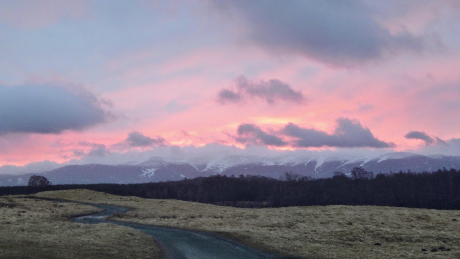
Sunset from Glen Strathfarrar
On Sunday morning, we woke at 6:30 and set off up the path below the dramatic cliffs of Sgurr na Muice at 8:30. The path climbs steadily up and across the face of Sgurr na Fearstaig to the ridge. Then on up to Sgurr Fhuar-thuill, the first Munro of the trip. 
Sgurr na Muice across Loch Toll a' Mhuic
We then carried on over Creag Gorm a’ Bhealaich (a Munro top) and onto Munro #2, Sgurr a Choire Ghlais. We had incredible views but there was a bitterly cold wind. We thought we could see the Cuillin on Skye but later worked out that it was the Torridon Hills. Down and up onto Carn nan Gobhar (Munro #3) and then finally on to Sgurr na Ruaidhe (Munro #4).

Looking East along the ridge
We headed South East to the Coire Mhuillidh and followed the path back into Glen Strathfarrar. A car was driving up the glen in the right direction even though it was a private road and it was after 6pm, when the gate closes. We stuck out our thumbs and it stopped to pick us up. The driver and passenger lived at, or were heading for Monar Lodge. We asked if we could have a lift back to our tent near Inchvuilt and they agreed. They asked if we had permission to camp and I asked if we needed it. They clearly weren’t crazy about ramblers wandering about but that’s Open Access for you (http://www.outdooraccess-scotland.com/Practical-guide/public/camping).
We were also asked if we had a car in the glen. There are some strange regulations surrounding access to Glen Strathfarrar (http://www.mcofs.org.uk/strathfarrar-access.asp). The gate is only open at certain times and you can’t have a vehicle in the glen overnight. Apparently this is because the wealthy Malaysian businessman who owns the glen is concerned about poaching. Nice of him to allow the road to be used during the day though!
Anyway, they very kindly dropped us off by our tent so we were most grateful as it was dark by now. This saved one and a half hours of walking along the road seeing if we needed to use our head torches or if our eyes would adjust to the dark.
On Monday we packed up the tent and crossed the Garbh-uisge burn. We walked along the northern side of Uisge Misgeach, past the Gleann Innis an Locheil Power Station then left the main track and a couple of men out deerstalking (on 24th Oct?).

Looking back into Glen Strathfarrar on Monday morning

We walked alongside the Allt an Eas Bhan Mhoir on a lovely stalkers path up to Loch Mor and found a place to put our tent at the southern end of the loch, just below the ridge (152350). First job, after putting the tent up - dig a deep poo hole.
We’d had another day of good weather although it was cold and windy out of the sun. A south facing corrie would have been sunnier but a lot windier.
Monday night had been cloudless so we awoke to a frosty scene with fantastic views of the stars. You could see The Milky Way stretching across the sky and Orion’s Sword.
On Tuesday we set off Eastwards, at first through frosty grass, then curved round South onto Bealach Toll an Lochain. We only had light packs today. Like Sunday, we could leave a lot of stuff in the tent. Fully laden with 5 days of food my pack weighed about 15kg so these lighter packs were a pleasant change. We ascended Creagan Toll an Lochain onto the end of the very long An Riabhachan ridge. We followed this over the summit (Munro #5) and then down and up to An Socach (Munro #6).
A fence post, an inversion over Loch Monar  and me. (All photos taken by Dorothy)
Once more, great views but a cold wind. Coming down from An Socach we were surprised to meet people in such a remote spot - two very friendly guys from Newcastle. We returned to the tent the way we came. Thus climbing An Riabhachan twice.
The weather changed overnight and it was very blowy in the tent. We packed it all up in light rain but it soon eased off. The wind didn’t ease off though. Back up on the ridge it was very strong with gusts that forced you to stand still and lean on your walking pole until they’d passed. The packs were quite a bit lighter now we’d eaten nearly all the food. We still had the litter and some unfinished Nuts and Trail Mix. I think we took a bit too much of that.
We battled our way to the top of Sgurr na Lapaich (Munro #7) and hid behind the cairn that surrounded the trig point. The next bit was tricky as some of it was over slippery boulders. By using the map, compass and Dot’s good path spotting skills, we kept to the right of the spine that goes East from Sgurr na Lapaich and found the path down to Bealach na Cloiche Duibhe. It was then a steady plod to the top of Carn nan Gobhar (Munro#8), once again in strong gusting wind but mixed with rain by now.
Finally, some respite from the wind as we headed for the col before Creag Dubh then S and SSE to join the ugliest new hill track I have ever seen. A wide area at 203330 had been completely flattened by vehicles and it was very difficult to cross in the wet without sinking right in. We followed this ridiculously wide track down to the dam and back to the van.

Loch Mullardoch in the rain.
The cramped van seemed like total luxury. We had been very lucky with the weather, although we now had a fair bit of wet stuff. We were lucky to get that lift and lucky to get across the bridge. All in all, an amazing trip and 8 Munros ‘bagged’. An Socach took Dot to the half way mark (141) and I now have 24 left to do!


Sunday, 17 July 2016

2016 Half Way Through


Well, I'm about half way through and it's going really well. The Family Week at Derwentwater was fun. There were a few issues with using the Launches on Derwentwater. Believe it or not because there was "Too much water in the lake"!

Not too much water in Sorrento. Very busy area though, especially trying to drive round to the Amalfi coast. We went to Pompeii and Herculaneum as well walking on the "Path of the Gods".

View from the Path of the Gods
HF were good enough to let me spend a week checking out the routes for the Munrobagging holiday, I then lead on a normal Glencoe Guided Walking week before leading the first HF Munrobagging holiday. I was lucky enough to experience 3 weeks of amazing weather. On the Munrobagging holiday we did ten Munros: Beinn Sgulaird, Stob Ghabhar, Stob a Choire Odhair, Binean Mor, Na Gruagaichean, Carn Liath, Stob Poite Coire Ardair, Creag Meagaidh, Aonach Beag and Aonach Mor. Amazing views from Colonsay to the Cairngorms.

Loch Leven
I then had a week leading for HF in Dolgellau. This area around southern Snowdonia is a bit of a hidden gem. How about this for beatiful singing by the hotel staff!


Next up was a week at Adelboden in Switzerland. This is a beautiful place looking just like the traditional Chocolate Box. Once again some lovely weather. So easy to get to the walks using local cable cars as well.

View from our hotel balcony
I am now writing this from Zakopane in Poland. Again, very easy to get to the walks using cable cars, chair lifts and local buses. Very busy here but so lovely to see so many Polish Working Class families out walking with their kids in the Tatra Mountains. We have had three days of good weather, if a little misty at times. It was a bit wet yesterday when we walked in Slovakia and today it has been throwing it down all day. We just went for a short walk this morning.

Sheltering from the rain in Tatra Mountains but still smiling


In between I've been on a two day Outdoor First Aid Course and a couple of one day courses: Geology of Snowdon (held in pouring rain) and Mountain Flora and Fauna (another slightly damp day in the Lake District).

Dot and I also went to New Zealand in February. So a pretty amazing year so far.

Saturday, 31 October 2015

2016 - Walks Leading with HF Holidays


I now have all my locations for leading walks with HF in 2016. So really looking forward to next year:-
  • Derwentwater (Lake District) - 1 week, 
  • Sorrento (Italy) - 2 weeks, 
  • Glencoe (Scotland) - 2 weeks,
  • Adelboden (Switzerland) - 1 week,
  • Mayrhofen (Austria) - 2 weeks,
  • Glencoe (Scotland) - 1 week,
  • Norcia (Italy) - 2 weeks,
  • Coniston (Lake District) - 1 week.
Details available at www.hfholidays.co.uk

Tuesday, 27 October 2015

Sixteen Munros!

The last few months have been very productive from a Munro bagging perspective. We had a lovely holiday at Balmacara near Kyle of Lochalsh with friends and family where we climbed two Munros on the North side of Glen Shiel; Sgurr a' Bhealaich Dheirg (peak of the red pass) and Saileag (little heel). We also walked on Skye and had a lovely walk to what's known as the Gates of Affric (Bealach an Sgairne).
The Cuillin on Skye

Then in the first week of October, Dorothy and I took the Camper Van to Loch Lomond. We parked up at Inveruglas and climbed Beinn Vane (middle hill), returning via the Loch Sloy Dam. Good facilities at Inveruglas, a cafe and loos and no objections to overnight stays. Very enlightened. Then we drove to Arrochar and parked in a secluded section of the car park near a sign saying 'No Overnight camping'. From here we climbed Beinn Narnain (hill of notches) and Beinn Ime (butter hill). Good views on both days.

 
The Cobbler from below Beinn Narnain.


We then drove round to the head of Loch Fyne. Parking at the start of the next day's walk was conveniently close to the Loch Fyne Restaurant, where we had our dinner. Next day we had a long walk to the summit of Beinn Bhuidhe (yellow hill). It was a long walk in from the head of Loch Fyne to Inverchorachan and then a steep ascent to Beinn Bhuidhe. Once we reached the upper corrie the rain started and on the ridge it was difficult to stand up because of the wind and driving rain. Dot and I pushed on to the summit to find the smashed trig point and then struggled back down to the upper corrie. We then followed the very ugly track created by the Hydro Scheme back into Glen Fyne. We were glad to be staying in bed and breakfast that night as it gave us a chance to dry out.

Inverstrae B&B was very welcoming. From here we climbed Beinn a Chochuill (hill of the hood) and Beinn Eunaich (fowling hill) in better weather.

We were at home for a week before the forecast of high pressure over Scotland tempted us to load up the van for another trip. We drove to Glen Affric by Loch Beinn a' Mheadhoin.

Loch Beinn a' Mheadhoin
Again a lovely car park with loos! On the following day we ascended Toll Creagach (rocky hollow) and Tom a' Choinich (hill of the moss). Some incredible views.

That evening we drove to Loch Cluanie and parked down the road from the Cluanie Inn. From here we climbed Ciste Dubh (black chest) and Aonach Meadhoin (middle hill). The next day we did A' Chralaig (the basket) and Mullach Fraoch-choire (heather-corrie peak) along a magnificent ridge. Haggis neeps and tatties in the Cluanie Inn went down well with a couple of pints of 'Wilder-ness' beer.

Dorothy walking down Gleann nam Fhiadh on the way to Toll Creagach.

The South Glen Shiel ridge in early morning sunlight from the slopes of A' Chralaig
The last two Munros were Sron a' Coire Ghairbh (nose of the rough corrie) and Meall na Teanga (hill of the tongue). We did these from the car park by the eas Cia-aig waterfalls on the Mile Dorcha near Loch Lochy. This was a long walk made even longer because we had to follow a diversion while a hydro scheme is being created.


This Munro bagging thing is taking off. Steve and I are offering 3 Munro Bagging HF Holidays based from Glencoe next year. (https://www.hfholidays.co.uk/holidays-and-tours/munro-bagging-glen-coe/).


Friday, 21 August 2015

Party Management at Minor River or Stream Crossings

The Mountain Leader Training Association literature contains plenty of information about the technicalities of managing serious river crossings and quite rightly emphasises the need to avoid them if at all possible. However, here I would like to discuss the management of relatively inexperienced groups on more minor river or stream crossings. The sort of situation where you might comfortably just hop across on a few rocks if you were on your own, where the aim is to try to get across without getting wet feet. Nothing more difficult than that.

I have hopped across a lot of rivers and streams, especially in the Scottish Highlands and the chances are that I will have had a lot more experience of doing this than anyone else in my group. 

Nevertheless, I have found that a previously cohesive group of people who were happily following and trusting me suddenly start to behave strangely when they reach a river or stream. Some people will be worried. Some seem to acquire a desperate need to find their own place to cross. Some will underestimate the risks and others would follow you straight across putting their foot onto a rock the minute your foot left it if you let them. It’s a very strange business and it seems to happen with even the smallest of streams despite the fact that it’s so easy to slip and hurt yourself as soon as you step on slimy wet rocks.


So unless it’s really trivial, I strongly recommend stopping the group just before you get to the stream and telling them to wait. Go take a look and come up with a plan. A bit like managing a group in the mist when you need to take a compass bearing.

You’ve probably arrived at the stream where the path crosses it and this is likely to be a good bet under normal conditions but perhaps there has been a lot of rain. You need to make sure that the least stable person can get across here. Bearing in mind that some stepping stones might be slightly submerged or wobbly, are there some possibly slightly submerged, additional rocks that you could stand on alongside those that he or she might use? Could you stand there and hold out a hand to help them balance? Can you or someone else lend them a walking pole that could be passed back? Would it help if you took their rucksack across for them? If you don’t feel they could cope, then you need to tell the group to take a break while you look elsewhere.

At this point you probably need to manage the people with a desperate need to find their own place to cross. Explain that you have had a lot of practice at crossing rivers and you need to find a place where you not only feel everyone can cross but where the risks are minimised. It may be that there are several large dry stepping stones close to each other that seem easy but if someone did slip they could bang their head, get soaked or worse. It might be better to accept a greater risk of slipping where the only consequence is wet feet. Explain that you are responsible for getting everyone across safely and you would like them to help each other to get across as a group. You don’t want to find out that all the people with good balance and long legs are already on the other side.

If you really can’t find a crossing point nearby, to suit the least stable person then the whole group is either going to have to walk upstream until you can, or you are all going to have to go back. If you are going to head upstream make sure they understand that you are looking for a suitable place to cross and think about how you will get back to your original route safely. Do tributaries on the other side run through gorges for example?

Let’s assume that you have now found somewhere that meets requirements. Go across yourself, leave your rucksack on the far bank, then come back and place yourself in the best position to help people. Have your best two crossers go first and last so that they can help people start to cross and to step onto the far bank. Explain the plan to the whole group and then execute it.

Does all this seem like overkill? Well just pick out the bits that you feel are appropriate but at least remember to manage the situation. Don’t just hop across and hope people will follow you.

Monday, 29 June 2015

Sardinia

I've been learning Italian on and off for about 18 months so I was keen to go on a walking holiday in Italy. Sardinia sounded interesting and a bit different so when we saw that there was a Cicerone guide book, we thought we'd give it a try. Dorothy and I had previously had a good holiday in the Stubai Alps on the Rucksack Route using the Guide Book by Allan Hartley so we bought 'Walking in Sardinia' by Paddy Dillon and planned the trip for April.

We planned to spend ten days there from Friday to Monday - flying from Stansted to Alghero and staying at Dorgali for three nights, Baunei for four nights and Aritzo for the last three.

We'd booked the flights, the accommodation and the car hire on the internet so what could possibly go wrong?

We were expecting a Fiat Panda but they gave us a Renault Jeep, which is quite a large chunky car. Imagine a mini version of a Hummer. Once I'd got used to the controls, sitting on the left and driving on the right, we felt able to turn on the radio and listen to people talking Italian very quickly, but later on we were pleased we had the Jeep!

The Bed and Breakfast place we stayed at in Dorgali was excellent and they were happy to provide us with practically anything for breakfast. This was good as I don't think the default breakfast of sweet biscuits and rolls would have worked for us every morning.

One of Many Lizards
On the first day we walked over Monte Bardia and Cuccuru Cazzeddu from Dorgali to Cala Gonone and back. Cala Gonone is by the sea on the East coast and this was a combination of  two of the walks in the guide. It took us longer than we expected. As the guidebook said, the paths are rocky and stony and when you get there you discover how much this slows you down. The limestone scenery is very dramatic and we had a pleasant if slightly expensive salad in a restaurant overlooking the harbour.

We had planned to get some food for our packed lunch from the supermarket the next day but then we realised that it was Sunday and all the shops were shut. Never mind, we had a few nuts and some fruit. We'd manage. We drove to Oliena and parked by the church. The priest was out chatting to local residents. I hope we didn't pinch someone's parking space.

We walked up a very windy road then a track with many zig zags to finally reach the top of Punta Sos Nidos (1348m). Unfortunately it was bit misty at the top. Tricky route finding following little cairns and rocks in trees got us back via scree and forest tracks. There are so many Holme Oaks here. Also many white Asphodels.

Holme Oaks in the Sunshine
We'd eaten in a couple of different restaurants in the evening and enjoyed some inexpensive local wine along with free glasses of Mirto, the locally made myrtle berry based liqueur.

The next night was to be at an apartment in Baunei but first we went to see the Nuraghic village of Tiscali. The internet company is named after it and it is in a collapsed cave high up in the hills. The broken bridge described in the guide book had been replaced so we didn't have to balance across the river on boulders. Because of the ceramics that were found there, it is thought that the village was originally inhabited in the Bronze Age but also lived in during Roman times.

Tiscali
When we got to Baunei there was no sign of the owner of the apartment. My rudimentary Italian came in handy when I phoned him and explained that we'd booked the next four nights but he was surprised by this. He drove over to meet us and explained that we couldn't stay there because the bathroom was broken and the workmen were coming to repair it in two days time. He did find us an alternative apartment but it was 20 km away. He thought we'd be pleased as it was by the beach. Maybe that's where Victoria Beckham goes but we'd wanted the lovely view from the balcony and the close access to the mountains offered by the original apartment. He was trying to be helpful and as it was getting late, the simplest option was to go with the flow.

Unfortunately Dorothy had twisted her ankle a couple of times during the first three days so we took it easy the next day. I think we both needed a more relaxing day to be honest so we stocked up on food to cook in the apartment and had a look round the village of Santa Maria Navarrese. There are three picturesque rocky islands off shore and we had a nice lunch in a restaurant.

View from Santa Maria Navarrese
By now we were halfway through the holiday. On the Wednesday, we strapped up Dorothy's ankle and drove back through Baunei to Bar Su Porteddu near Golgo and followed the path to Cala Goloritze. This is by the sea and features in several local postcards with its sea tunnel and rocky limestone spire. We bathed our feet and Dorothy painted while a local school party played on the beach. We speculated that it was officially a Geography trip but in reality a pleasant day out for all concerned including the teacher. I expect they arrived and left by boat judging from the footwear. On the way we saw wild sows with their piglets snuffling about as well as goats. We made a detour to the top of Punta Salinas from where we could see a lot of the North West Coast and we met the boars on the way back.

Looking North from Punta Salinas
On Thursday I drove to Trieu and we went to see the Tomba dei Giganti (Tomb of the Giants) - an arc of stone slabs flanking a very large passage grave. The walk continued past many springs and fountains (sorgenti e fontane) often set into elaborate walls, troughs or even buildings. We often saw locals filling up plastic bottles from these springs so they are probably felt to have health benefits. I almost drove into the tailgate of a van and had a bit of a 'misunderstanding' with a woman on a zebra crossing on the way there, but no harm done!

Tomba Dei Giganti
On Friday we went back to Santa Maria Navarrese and walked along the cliffs to Pedra Longa, another huge limestone pinnacle. We then drove over very twisty mountain roads to the village of Aritzo which is further inland and where the geology is very different. Here there is granite and schist rather than the limestone with occasional basalt lava flows we had seen along the East coast. Allow plenty of time if you are using these twisty roads.

We stayed in a family run hotel and the next day we walked up Brunca Spina and Punta la Marmora, the highest point on the island at 1834m. From here you should be able to see most of the island but for us it was bit hazy. The drive to the walk was interesting. The road ran out of tarmac at one point and just became a rough track. Then a series of ridges made from hard mud, before going back to a track and after about a kilometer going back to tarmac. Good job we had the Jeep. Did the budget run out?

Back at the hotel I asked the owner about it. "Questa strada è rotto" (This road is broken) I said pointing to the map. He explained that it had been like that for 6 years and they tried to avoid going that way in the winter!

On our last walking day we drove to Tonara, a nearby village where they make Nougat. Unfortunately it was Sunday again so we couldn't try it. We ascended Punta Muggianeddu, an excellent viewpoint, on good tracks and extended the walk to include Punta Perdu Abes.

Artistic Schist
The weather had been more cloudy for the last two days which made for more pleasant walking conditions. Before that it had been warm but nevertheless quite bearable. We'd only had to put up with a small shower all holiday. Given the number of flowers we saw, especially some gorgeous purple crocuses, I'd say this was a good time of year to go.

No problems on the flight back. I had scuffed the rubber on the side of the Jeep and we were a bit worried about it. Over the week the vehicle had become nice and muddy so that the scuff was almost unnoticeable but on the way back to the airport the clouds opened and cleaned the car! We got away with it though.

The guide book was really useful but Paddy walks quite a bit faster than us.


Friday, 13 March 2015

Progress with the Munros


Having failed to do any Munros in 2014, I was keen to get the ball rolling again and get some winter walking in before spring had sprung. I also wanted to try out our mini camper van, a converted Citroen Berlingo. 

On Saturday I drove to Glen Feshie, which is directly South of Aviemore and spent the night in the van in the parking area at the end of the road. Bearing in mind the fact that many rivers were in spate, I thought it would be best to cross the Feshie, walk down to Carnachuin and cross back thus avoiding crossing the Allt Garbhlach. Unfortunately the second bridge had been washed away so I had to retrace my steps back to the first bridge. This added about 6 km (90 minutes) to the walk.

In the end I did manage to cross the Allt Garbhlach using a fallen Scots Pine.

Natural Bridge
The way up Mullach Clach a Bhlair (1019m) is on a wide track nearly to the summit but at the top there were White Out conditions. At one point I was walking in what seemed to be complete space with no reference points just keeping the compass needle between the two fluorescent strips on the compass.

I returned the same way and drove to the parking space at the end of the C Road, North West of Newtonmore. The forecast for the following day was for gales later, so I decided to start off early.

Sunday turned out to be quite an adventure and I was on my way by 6.30 am. There was a beautiful Sunrise.

Sunrise over Newtonmore

Sunrise over Newtonmore


I walked to Glenballoch then headed NW alongside the Allt Fionndrigh. (Allt means 'river' in Gaelic, known more colloquially as a 'burn'). After about 3 km there is a bridge across the river.

Bridge over the Allt Fionndrigh
I then crossed over the bealach (col) to Glen Ballach and followed that to it's head, turning SW to follow a ramp of hard snow and ice to the bealach below Carn Dearg (945m). By now I had my crampons on and my ice axe in my hand. As there was a strong wind with snow and ice crystals I also had my balaclava and snow goggles on.

Summit of Carn Dearg
Flushed with success, I decided to work my round to Carn Sgulain. This is about 8 km across featureless terrain but there is a line of fence posts so navigation should be fairly straightforward, I thought. As I went up and down over Carn Ban, Carn Balloch and Meall a' Bhothain I was finding the constantly strong side wind very tiring. Following the fence posts is fine until they disappear below deep snow. At these times I was back in White Out world.

It was hard snow so I put the ice axe away but kept the crampons on. By the time I reached Carn Sgulain (920m) I was exhausted. A' Chailleach would have to wait for tomorrow. I descended to the Allt Cuil na Caillich and over the shoulder of A' Chailleach to follow the Allt a' Chaorainn. The shoulder was very hard packed snow and even in my crampons I had to perform a small ice axe self arrest at one point.

I got back to the van at 5.30. A bit of an epic. It was a very windy night with the van being buffeted by gusts of wind and rocking me in my sleeping bag.

The next day I was away at 8 am and trudged back up alongside the Allt a' Chaorainn to a point East of A' Chailleach (The Old Lady). At this point the burn was narrow enough to cross. Getting from there to the summit of A' Chailleach (930m) involved crossing some more hard packed snow fields so the ice axe and crampons were deployed again.

It was snowing when I set out and on top it was cold and windy but the sun came out later and the combination of the sun and snow was lovely and made for some nice photos.

A' Chailleach on the left

Summit of A' Chailleach

Looking back at the summit of A' Chailleach

The cornice over the cliffs to the East of A' Chailleach

Allt a' Chaorainn
I got back to the van at about 3 pm and drove to the car park below Creag Meagaidh at Aberarder by Loch Laggan. There was a Plas y Brenin Minibus there all night so there may have been a group in snow holes somewhere.

I started walking at 7am as, once again, bad weather was forecast for the afternoon. It was quite windy but sunny on the way up with another lovely sunrise and good views of Creag Meagaidh and the distinctive bealach known as 'The Window'.

Sun Rise over Loch Laggan

Creag Meagaidh and The Window
I climbed directly to the top of Carn Liath (1006m). There were some more snow fields but not steep or hard enough to require crampons. At the top it was gale force. I can't remember ever experiencing such a strong wind. I hid behind the summit cairn to put my waterproof jacket on and get my walking pole out. I really thought I was going to have to crawl off the top at one point but just managed to walk off using the pole as a third leg. You can't see the wind in a photo so you'll have to use your imagination.

Creag Meagaidh from the summit of Carn Liath
I was back in the car park by 11 am and with the bad weather coming in I decided it was time to go home. Five more Munros bagged, 55 to go. The van is great but even for one person there isn't much space. Experiencing Scottish Mountains in all these different weathers is amazing but now creature comforts beckon.