Monday, 6 May 2019

Benimaurell in Valencia


Getting away to sunny places so early in the year has been wonderful but I must admit that my lack of Spanish does make things a bit more challenging and I found this to be particularly true on the HF Holiday that I was leading at Benimaurell in Valencia last week.

One of the best things about the place is its isolation but that means that you are unlikely to find people who talk English outside the hotel; including the manager of the transport company. Valencian is a dialect of Catalan so, although I have no doubt that people would understand you if you spoke Spanish, it is not their first language.

Many of the walks are in the local area and, on the two days when we use a coach to travel to Lliber and to Parcent, the journeys are short. This means that you really get to explore the local area which is famous for it's dramatic rock architecture and the Trails built by the Mozerabs.

HF used the hotel a few years ago. In fact we went on the holiday in 2010. They stopped going there for a while but are now back. We were there for the second and third week of the new holiday. The Field Adviser was there with me for a week and he'd had to make a lot of amendments to both the walks and the walks descriptions. This doesn't make things any easier.

Compared to similar HF European holidays, the walking is fairly easy which is fine on a lovely sunny day as people can come back to the hotel and relax by the pool. We had several days like this but also some cloudy days. In fact, when we arrived it was into day 2 of 4 days of torrential rain that created a lake behind Isberts Dam in the Barranc de l’Infern (Hell's Ravine). Isbert had the dam built to create a reservoir in the ravine but all the water drained away through the limestone.

View from Hotel: Reservoir behind Isbert's Dam before it drains away
Getting to the dry side of the dam involves going through the 90m tunnel built during its construction. After all the rain this was a little tricky for some of the way

The tunnel
The hotel is in a wonderful location just above the village of Benimaurell where the two small shops are indistinguishable from the other houses unless you know where to look. The food was excellent and by 10pm most people were ready for bed, full of lovely wine and local food.

Hotel Alahuar above the village of Benimaurell
I would definitely recommend it as a relaxing holiday set amongst amazing scenery in an area rich with history. I must admit that I prefer the higher mountains myself. My next HF lead is in Schenna in the South Tyrol. More my kind of country.

Saturday, 13 April 2019

Glencoe Field Advisor

I feel very honoured to have been asked to be a Field Advisor for HF Holidays, especially as it's at their house near Glencoe. There are two of us doing this at Glencoe. If you've read this blog from the beginning you will know how special the place is to me, having led walks from there in the late 70s and early 80s.

Last week I was leading walks on the Glencoe Guided Walking Holiday. So it made sense to go early to set up the leader office and to check out potentially dangerous snow patches, update some walks or help to create new ones. Leaders are provided with a section of map showing where a walk goes, a written description of the route and notes about interesting aspects of the walk. So these are the documents that have to be updated or written. This is much easier now we have digital mapping software.

On the first day I discovered that the Forestry Commission had decided to harvest some of their trees right over the place where three of our walks go. I went to have a look and there was definitely no way through. I did find a way to save one of the walks by coming down the ridge rather than the valley but the other two will be out of action for a year. They say that they will re-instate the path after the work is finished. Let's hope so!

Forestry Works Notice
On another day I went up into the hills above Kinlochleven to look at a path we might use for a future walk. It was one of those days when you experience all four seasons. One minute it was snowing and the next it was a lovely sunny day. Allegedly they have a saying in Scotland: "If you don't like the weather, or even if you do, just wait 10 minutes."

I took these photographs:

Kinlochleven and Loch Leven in the morning

Sgurr Eilde Mor and its reflection in the lochan below

Binnein Beag and the Grey Corries from Sgurr Eilde Beag

The Mamores from Binnein Mor South Top

Loch Leven in the afternoon

Friday, 29 March 2019

Madeira

Last week Dorothy and I flew to Madeira where I was leading walks for HF Holidays. There is plenty of good walking on the island but it is a bit more built up than La Gomera (see previous post). Some of the walking is along Levadas.

Levada Walking in the Laurisilva Forest
The Levadas stretch across the island carrying water from one place to another. We walked through agricultural land, moorland and Laurisilva Forest.

There is huge variety of plants on the island including exotic plants like cacti as well as plants you might find in the UK like Gorse.

Gorse in bloom
We didn't just walk on Levadas. There was a sightseeing day around Funchal, a day high up in the mountains and a day on the St Lawrence Peninsula with its dramatic cliffs.

St Lawrence Peninsula

Sunday, 10 March 2019

La Gomera

I have just got back from leading walks for HF Holidays in La Gomera, in the Canary Islands. We fly to Tenerife and then take the ferry. The island has been described as looking like a lemon squeezer because of all the ridges and valleys (barrancos) that run down from the highest point, Garajonay. The walking is on good paths but many are very rough and often on the sides of cliffs that look as if they'd be impossible to climb or traverse. Above Agulo is the amazing glass Skywalk.

Skywalk above Agulo
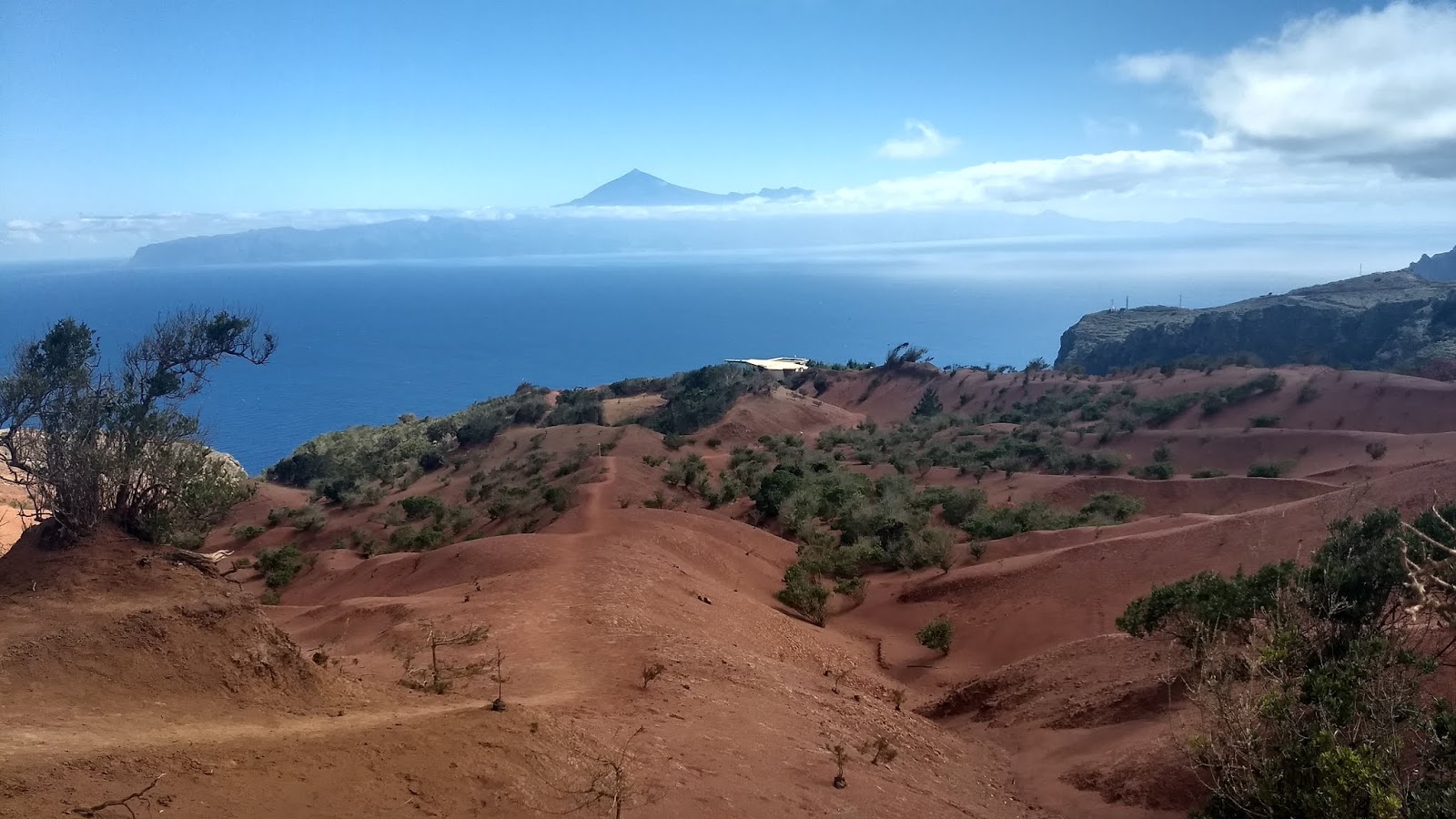
Above the Skywalk there is a landscape of red earth reminiscent of the Australian Outback. La Gomera is volcanic but has not seen any seismic activity for two million years. That's plenty of time for erosion to create all the barrancos and expose the rock beneath.

Mount Teidi on Tenerife looms over the Skywalk building
Plugs of harder rock have been left behind creating interesting shapes and structures with lots of basalt columnar jointing like the Giants Causeway in Ireland.

The path below El Sombrero and other rock structures

Walking on Basalt in the beautiful Guarimiar Barranco

Everywhere you go you are surrounded by Prickly Pear Cacti, Euphorbia and Agave. There is layer upon layer of strata caused by different types of volcanic eruption and caves where gas bubbles in the lava once were. Often you get views of the sea and other Canary Islands. Some walks take us to remote beaches with crashing waves. It really makes for fantastic hiking.

The Hermigua Valley
Great to get some sun at this time of year. Today it snowed in Hebden Bridge!

Wednesday, 21 November 2018

Patagonia

Dorothy and I joined six other people on a hiking tour of Patagonia organised by Explore. We flew from Manchester to Heathrow then on to our hotel in Buenos Aires, where we met our tour guide Lucia. We were given a guided tour of Buenos Aires by Lucretia, a local guide. The tour included the incredible La Recoleta Cemetery and the colourful La Boca. Dot and I visited a couple of Art Museums, one of which had a huge temporary Turner exhibition! In the evening we eat out. They know how to do a good steak in Argentina. While I'm on the subject, they also serve a large variety of cakes for breakfast.

Buenos Aires
Next day we got up at 2am to fly to El Calafate where we were met by a minibus and driven to El Chalten. We saw Guanacos, Condors and a Choique on the way there and we had time for a short walk to a small hill with views of Mount Fitzroy and El Chalten. Mount Fitzroy had a little bit of cloud above it. this was appropriate because it was previously called Chalten which is derived from a word in the native language meaning 'smoking mountain'. Francisco Moreno called it Fitzroy after Robert Fitzroy who was the captain of The Beagle, the ship that Darwin sailed on.

The next day we were driven to El Pilar where we met our excellent and very patient guide Foocau (phonetic spelling) who took us up to Poincenot Camp. Here we were shown to our tents with mats, inflatable mats and thick sleeping bags. Nice food was provided and the view of Mount Fitzroy from the camp site was amazing.

Mount Fitzroy from Poincenot Camp

Mount Fitzroy
Me above Laguna Sucia

The next day we walked to the lake below Cerro Torre. The weather remained good all morning but it did get very windy and wet later on and Cerro Torre was in cloud when we reached Laguna Torre. We hiked back to our hotel in a very wet El Chalten and the next day went on a boat trip on Lago del Desierto. At the far end of the lake is a military outpost as it has been the subject of a territorial dispute between Argentina and Chile in the past. We saw a Black Faced Ibis there. In the evening we were driven back to El Calafate

The Group
The next day we were up early again to take a very plush service bus across the border to Puerto Natales in Chile. The town is on the Pacific Ocean but only by a very tortuous route.

"The province where Puerto Natales is located was named Última Esperanza (Last Hope) by the sailor Juan Ladrilleros, who was seeking the Strait of Magellan in the year 1557. It was his "last hope" to find the Strait after exploring the maze of channels between the waters of the Pacific and the mainland. It was not until three centuries later, in 1830, that another major expedition sailed through the fjords and channels of Última Esperanza: the British expedition of the sloop HMS Beagle."  - Wikipedia

We were introduced to our very enthusiastic Chilean Guide, Juan Pablo and on the next day we boarded a minibus that took us along a dirt road to Lago Grey. We had a fairly strenuous 2 hour walk up to a viewpoint about 600m above the lake with fantastic views across the Torres del Paine National Park.

Dorothy painting above Lago Grey and Grey Glacier (Icebergs in lake)
We then boarded another boat to take us on a trip below the snout of Glacier Grey that dropped us off at Camp Grey where we had dinner in the canteen and slept in our yellow tent with no inflatable mattress this time, just the normal mat and comfy sleeping bag. Quite hard!

From Camp Grey we walked to Frances Camp, where we spent two nights. We had incredible views of the Cuernos del Paine (The Horns of Paine) along the way and even closer views when we walked up into the French Valley. We were incredibly lucky with the weather.

Walking towards the Cuernos del Paine
Looking South with some amazing clouds. This photo looks like a painting!
Panoramic view of the Cuernos and French Valley

We then had a relatively easy day walking from Camp Frances to Camp Torres followed by a very long day indeed. We had breakfast at 6:30 and started walking at 7:15 so we had to be awake at 5:30 so we could 'faff about' with our gear. We walked up to the Chileno Camp, to which beer was being delivered by a train of horses, and then on up a marked path on steep scree to a lake surrounded by a wall of rock. It was snowing. So unfortunately, we couldn't see much. We passed lots of people heading up there as we started off back down to Camp Torres. When they asked us if they had far to go we had to reply "to be honest, yes!"

On the way to Camp Chileno before it started to snow. Still very windy though.
We got back to Camp Torres at 5:30, having completed the 'W Trek', and piled onto a minibus to the Argentinean border and then back to El Calafate. Because the cafe we stopped at for dinner took an hour to serve us steak and chips, we didn't get to bed until 1:30.

The next day we were up early again for a 6:30 breakfast and a 7:30 departure on what was admittedly an optional trip. Six of the group went trekking on the Perito Moreno Glacier but, as we had walked on a glacier before, we were dropped off at 'the galleries' which are opposit the snout of the glacier. The glacier is constantly calving. In other words, you can see huge chunks of ice fall into the lake if you are patient enough. We were lucky enough to see a big tower fall off. We also went on a boat trip to see it close up.

Perito Moreno Glacier
The glacier is unusual because, unlike nearly all others, it is not receding. In fact, because there is land directly opposite the snout, it sometimes forms an ice bridge that later collapses. This is known as a Rupture. It is one of 48 glaciers fed by the Southern Patagonian Ice Field, which is the world's third largest reserve of fresh water.

We had a lie in before flying from El Calafate back to Buenos Aires. The next day we flew back to Heathrow overnight then on to Manchester and a train journey home.

It really was quite an adventure. I don't think it would be possible to pack more into two weeks and we were incredibly lucky with the weather. I'll leave you with a photo of a Caracara.

Caracara

Monday, 8 October 2018

The Last Munro

My last Munro - Ben Lomond

In 1976 I was working for Countrywide Holidays Association as a Kitchen Porter at Creag Mhor near Onich on the shores of Loch Linnhe. Having done my A levels, I didn't want to spend a long summer in London arguing with my parents so I'd taken this job in the Scottish Highlands with a company running walking holidays. They let the staff go on the walks on their day off so I joined the walk up Ben Nevis via the Carn Mor Dearg arete. That was my first Munro. 42 years later, I was at the top of Ben Lomond having ascended all 282.

My first Munro - Ben Nevis and the CMD Arete
I heard about the Munros and the fact that people tried to climb them all in 1988. This sounded like a great idea for a lifetime project. Could I do them all? I bought a copy of Munro's Tables (revised 1984) and ticked off the 34 that I was 100% sure I'd been up. At the time there were 277 Munros but in 1997, the Scottish Mountaineering club added eight peaks and removed one, bringing the total to 284. Because of improved surveying techniques, in 2009 Sgùrr nan Ceannaichean was found to be only 2,996 feet 10 inches high and in 2011 Beinn a' Chlaidheimh was found to be 2,998 feet 8 inches tall so they were struck off the list; bringing the total down to 282.

Celebrating on Ben Lomond
Munros are hills in Scotland with summits that are over 3000 feet above sea level. There is no strict definition of how much drop there has to be between two of them for them to qualify as separate peaks. However, Corbetts (mountains in Scotland between 2,500 and 3,000 feet above sea level) do have a strict definition. There has to be a re-ascent of at least 500 feet on all sides. "In 1992, the publication of Alan Dawson's book Relative Hills of Britain, showed that three tops not already considered summits, had a prominence of more than 500 feet (152.4 m). Given this they would have qualified as Corbett summits had they been under 3,000 feet." (Wikipedia). This forced the Scottish Mountaineering Club to revise the list of Munros so they took the opportunity to have a more sweeping review and that is why the list was revised in 1997.

The crack team ready for the final ascent. L to R - Wendy, Moya, Dorothy, Ann, Me, Liz and Gerry.

At present 6,419 people have registered their names as 'compleatists'. The list can be viewed here.  Once I have sent off my letter to the SMC my name will be added to the list. There will be many more people who have done it and don't want their names on the list of course. Before the internet existed, the names were printed in Munro's Tables. The 1984 edition lists 304 people.

Eating a slice of The Last Munro Cake with Dorothy (L) and Liz my sister (R). Thanks Moya.
'Munrobagging' is becoming increasingly popular. It has its critics. Many people say that they'd prefer to concentrate on the more interesting hills and aren't interested in their height or whether they are on someone's list. However, the list has taken me to many places I might never have had the incentive to visit and I am pleased to have done them in my lifetime.

What now? The Corbetts, The Munro Tops or another list ? I don't think so. I can go back, with Dorothy to revisit some of the best Munros that she hasn't done like Liathach in Torridon (as featured in the wonderful The Munro Show - check it out.). I can also pick out the hills I've wanted to do but de-prioritised because I was too busy Munrobagging.

Tuesday, 31 July 2018

A Grand Day Out

A couple of weeks ago I was fortunate enough to be leading walks for HF Holidays at Adelboden in Switzerland. Adelboden is in the Bernese Oberland. In the two weeks I was there I never had to put my waterproof coat on! It did rain occasionally in the evening and at night but that's fine.

There is no organised walk on a Wednesday so on 11th July I decided to go for walk on my own. I took the bus from Adelboden bus station to Unter dem Birg and went up in the cable car to the Engstligen Alp. An Alp is a high pasture and this is where the Alps get their name from. The Engstligen Alp was once a glacial lake in a hanging valley but it filled up with sediment. So it is now a wide flat area where cattle can be grazed in the Summer.

Every year the local people have the Alpaufzug, when a few hundred cows are driven up the narrow path beside one of the largest waterfalls in the Alps. This is an example of 'transhumance', a lovely word that refers to the act of moving livestock between winter and summer pastures.

As the cable car went up it went through a band of cloud and emerged into the sunshine. As I crossed the alp I could look up at the Tschingellochtighorn. It dominates the ridge between Adelboden and Kandersteg and looks like a castle.

Tschingellochtighorn across Engstligen Alp
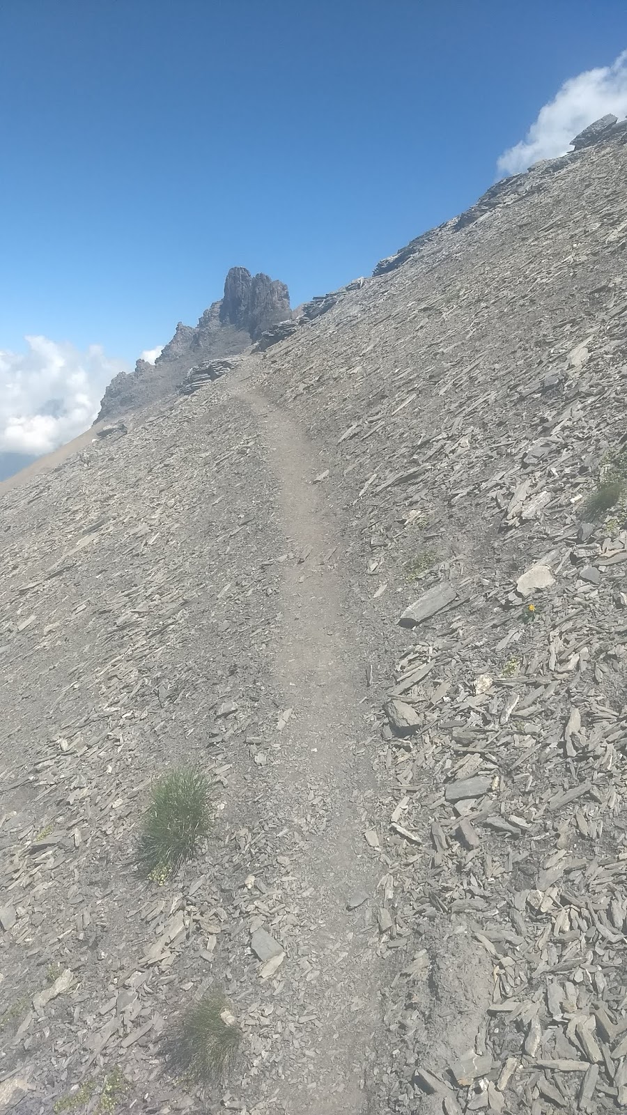
I was heading up to the ridge above Engstligen Alp on a path denoted on the map by a red dashed line. This means it will be harder than a continuous red line which denotes a good track or footpath but easier than a dotted line which may require climbing equipment. You never quite know which end of the spectrum it will be until you get there. In this particular case there were three small snow patches to cross and some scree with a fairly sketch path on it.


Once I was up on the ridge there were some great views and the walking along the ridge was pleasant and straightforward. You can enjoy the views so much more if you aren't having to look where you put your feet down all the time.

Selfie looking back along the ridge
Looking forward along the ridge at the side view of the Tschingellochtighorn
Looking down at the Engstligen Alp
I descended across another sketchy path over scree and then down a long ridge back to the top station of the cable car.

Sketchy path over scree to long ridge below
Looking up at the Tschingellochtighorn which seems to be made of very friable shale!

Route marked in red
Top station of the cable car.
It really was a grand day out! I love leading groups in the mountains but it does makes you appreciate the contrast and the peacefulness of a day on your own.